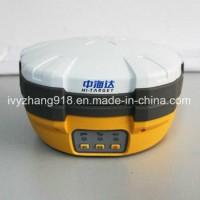
Product Name: Dual Frequency GPS L1 L2 Receiver with High Accuracy GPS Gnss Rtk System Differential GPS Model NO.: V90 Horizontal Line: 1 Vertical Lines: 1 Accuracy: 2mm Gnss Solutions: Gnss Antenna GPS Gnss: Gnss GPS Global Positioning System: Inside Gnss Glonass: Galileo Gnss GPS: Global Positioning Systems GPS Device: Gnss Rtk GPS Glonass: Gnss Simulator GPS Devices: Glonass Receiver Navigation Gnss: Portable GPS GPS Receiver: GPS Surveying Trademark: Hi-Target Transport Package: Cartonbox Specification: CE/ISO/FCC Origin: Chongqing HS Code: 9002209000 Product Description Dual Frequency GPS L1 L2 Receiver with High Accuracy GPS Gnss Rtk System Differential GPSWith a hi-tech, fully integrated design, the conveniently sized V90Plus is one of the most flexible choices for any measuring task. Built-in Linux3.2.0 operating system, pre-loaded multiple smart applications such as tilt surveying, electronic bubble calibration, NFC and voice DIY, V90Plus GNSS system provides surveyor industry-leading GNSS solutions.Feartures:Small and lightweight · only weighs 950g.·Measures Diameter 153mm x Height 83mm.Multi-constellation Tracking·220 tracking channels·Supports GPS, GLONASS, GALILEO, BDS, SBAS·NGS approved full-band GNSS antennaSmart Application·Offers tilt survey with a maximum tilt angle of 30 degrees.·Supports electronic bubble calibration·The internal NFC module makes Bluetooth communication quick and easy.·Intelligent voice assistance guides field operations. Voice can be DIY.·Standard Rinex data and HI-TARGET raw data recorded simultaneously.Optional Transceiver UHF Radio·The transceiver UHF radio enables switchable working modes between base and rover.·Three types of internal UHF radio provide different frequencies based on users requirements. The Pacific Crest TrimTalk© internal UHF radio is compatible with other radios.Multi-network Connection·Supports GPRS, GSM and WCDMA·Supports WIFIPowerful Battery·Powered by high-capacity (5000mAh) Li-ion battery to ensure full day operationRugged Design·IP67 dustproof and waterproof·Able to survive a 3-meter natural fall onto concreteTechnical Parameters:Satellite Signals Tracked Simultaneously220 ChannelsGPS..... Simultaneous L1C/A, L2C, L2E, L5GLONASS........Simultaneous L1C/A, L1P, L2C/A (GLonASS M only), L2PSBAS............. Simultaneous L1 C/A, L5Galileo............ Simultaneous L1 BOC, E5A, E5B, E5AltBOCBDS............................... B1, B2QZSS.............. L1 C/A, L1 SAIF, L2C, L5POSITIonING PERFORMANCEStatic and Fast Static GNSS SurveyingHorizontal............2.5mm+0.5ppm RMSVertical................ 5mm+0.5ppm RMSPost Processing Kinematic (PPK / Stop & Go) GNSS SurveyingHorizontal.............. 1cm+1ppm RMSVertical............... 2.5cm+1ppm RMSInitialization time....Typically 10 minutes for base while 5 minutes for roverInitialization reliability...Typically > 99.9%Real Time Kinematic (RTK) SurveyingSingle baselineHorizontal.............. 8mm+1ppm RMSVertical................ 15mm+1ppm RMSNetwork RTKHorizontal.............. 8mm+0.5ppm RMSVertical................. 15mm+0.5ppm RMSInitialization time.....Typically < 8secondsInitialization reliability....Typically > 99.9%Code Differential GNSS PositioningHorizontal............. 25cm+1ppm RMSVertical............... 50cm+1ppm RMSSBAS ... 0.50m Horizontal, 0.85m VerticalHARDWAREPhysicalDimensions (W x H)....153mm x 83mm (6.02inch x 3.27inch)Weight...950g (2.09lb) without internal batteryOperating temperature.... -40ºCto +65ºC (-40ºF to +149ºF)Storage temperature....... -40ºC to +75ºC(-40ºF to +167ºF)Humidity............. 100%, consideringWater/dustproof........... IP67 dustproof, protected from temporary immersion to depth of 1m (3.28ft).Shock and vibration......Designed to survive a 2m(9.84ft) natural fall onto concrete.ElectricalPower 6V to 28V DC external power inputPower consumption ≤3.5WAutomatic switching between internal power and external powerRechargeable, removable 7.4V, 5000mAh Lithium-ion battery in internal battery compartmentInternal Battery LifeStatic 12hoursRTK rover (UHF/GPRS/3G) 8-10 hoursRTK base 8 hoursI/O Interface1 xBluetooth, NFC1 x standard USB2.0 port1 x TNC antenna connector1 x RS232 serial port1 x DC power input (5-pin)Tilt Survey SystemElectronic BubbleCOMMUNICATIonNetwork CommunicationFully integrated, fully sealed internal WCDMA, compatible with GPRS, GSMWifi frequency is 2.4G, supports 802.11b/g/n protocolNetwork RTK (via CORS) range20-50kmHI-TARGET Internal UHF Radio(Standard)Frequency 450~470MHz with 116 channelsTransmitting power0.5W, 1W, 2W adjustableTransmitting speed....9.6Kbps, 19.2KbpsWorking range.......3~5km typical, 8~10kmoptimalPacific Crest XDL Micro Internal UHF RadioFrequency................403~473MHzTransmitting power......... 0.5W, 2W adjustableTransmitting speed........ Up to 19.2KbpsSupport most of radio communication protocolWorking range............ 3~5km typical, 8~10km optimalHI-TARGET External UHF Radio (Standard)Frequency...... 460MHz with 116 channelsTransmitting power.... 5W, 10W, 20W, 30W adjustableTransmitting speed...... Up to 19.2KbpsWorking range.......... 8~10km typical, 15~20km optimalPacific Crest ADL Vantage Pro External UHF RadioFrequency. 390~430MHz or 430~470MHzTransmitting power.. 4W to 35W adjustableTransmitting speed........ Up to 19.2KbpsSupport most of radio communication protocolWorking range. 8~10km typical, 15~20km optimalSYSTEM ConFIGURATIONSystemData storage.........16GB Internal storage (Support up to 32GB external SD card)Record GNS and RINEX format simultaneouslyData Formats1Hz positioning output, up to 20HzCMR: CMR, CMR+, sCMRx input and outputRTCM: RTCM 2.1, 2.3, 3.0, 3.1, 3.2 input and outputNavigation outputs ASCII: NMEA-0183 GSV, AVR, RMC, HDT, VGK, VHD, ROT, GGK, GGA, GSA, ZDA, VTG, GST, PJT, PJK, BPQ, GLL, GRS, GBSNavigation outputs binary: GSOFApplication:Construction Lay OutAbundant point and line lay out function, assistant by graph operation instruction, save your expenditure in practical construction.Electricity and TransportationFriendly function on power line route direction survey, distance survey and angle calculation; comprehensive survey functionality on road survey, center line, offset survey, profile and cross-section survey.CORS ApplicationSeamlessly compatible with CORS system, only one RTK rover can receive CORS difference signal and carry out data collection, construction lay out work.CORS Station EstablishmentHD-CORS apply profound experience and mutual technology, stable on operation, long distance on data transmission, is yur first choice for city continuous reference stations system.Control Surveyonly one investment you can get list of function, v30 dual frequency static survey accuracy can satisfy any requirements, config with mutual professional data solution software. You can easily accomplish various high precision control survey work.Data conllectionCotroller operation software designed for GIS application, convenient coding function, meets all your requirements in field data collection work.


